The Nàdòbìkana FIT Trail at Bonnechare Park features a barrier-free washroom.
nah-doh-bee ka-na Translation from Anishinabemowin: a trail used to get water or sap
Footprints In Time (FIT) Teaching
Take twelve giant steps for 12,000 years. Cut the last step in half. This half-step marks the short time Europeans have been on this land compared to the Algonquin People. ~ Migwech to Algonquin Elder Dorothy Commanda for sharing this traditional teaching with us in 1997.
Stable Roots
This point of land, where the Little Bonnechere River spills into Round Lake, is relatively unstable although at first glance it seems quite the opposite. Despite the presence of the expansive sandy beach and towering shade trees, this landscape is geologically young — though formed over thousands of years. And the reshaping never stops. In summer, the sands along the waterfront are subject to the continual lapping of waves; in winter, when the water freezes and expands, the ice pushes hard at the shoreline. Up-river, erosion continually undercuts the sandy shoreline of the outside bends and deposits sediments on the inside bends.
Thankfully, there is vegetation here! For all the trees and foliage you see growing above ground, there is a corresponding network of roots growing underground. The sandy soil is held together by the roots of towering pine and birch trees, along with a succession of shrubs and plants that thrive lower to the ground. All of this vegetation plays a key role in bank stabilization.
Human and natural activity can dislodge new seedlings, but within Bonnechere Park care is taken to support ecological integrity by allowing their natural growth. A tangle of roots captures sediment and debris that begins to form soil capable of supporting the seeds of other plants, which ultimately makes for more soil and more stability. This process repeats itself over and over so that the vegetation — and a stable landscape — is sustained.
It has been like this for thousands of years. You and I have a responsibility to keep it so.
Pikwakanagan Elder Dorothy Commanda who shared the Footprints in Time teaching with us in 1997.
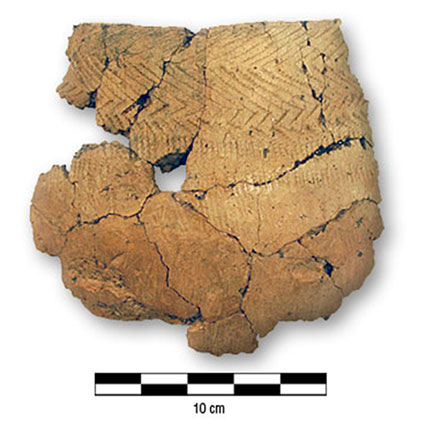
Woodland clay pot recovered from Round Lake shoreline.
A Good Place to Camp
Historical maps indicate that the location where the Little Bonnechere River enters Round Lake has shifted over time. This shifting by natural agents of moving water and ice that keep the sands clear of vegetation, has also revealed signs of human habitation long past in the form of ancient artifacts.
It was on this beach in 1991 that a Bonnechere Park visitor noticed a strange-looking object just where the waves wash onto the sand: a projectile point possibly 4000 years old. A few years later, after a winter of strong ice-push from Round Lake damaged a shoreline retaining wall, more evidence of human activity was revealed in the form of fragments of a Woodland Era clay pot.
Archaeologists tell us that this pot may date back a thousand years, perhaps to when a family of Algonquin People had an encampment not far from the beach. The children probably waded in the water, chased minnows and wondered what the parents had prepared for a warm meal from the gifts of Mother Earth that they had gathered in the wetlands and waters nearby.
Today Bonnechere Provincial Park protects the resources which were hunted and gathered in the past, along with artifacts that represent human activity, and preserves them in the earth beneath our feet. But it’s important to remember that just as it’s been for thousands of years, we humans are still leaving footprints in the ever-changing sands of this beach and riverine woods.
Remember to tread lightly so that we can play our part in protecting this landscape for generations to come.
Highlights
Woodland Pot
River Meets Lake
Ecological Integrity
Travel and Trade
Pick up the trailhead from the accessible parking area near the boat launch in Bonnechere Park.