The twin trunks of Payne's Pine stand out against the surrounding landscape.
North Meets South
Payne’s Pine Trail meanders through a section of the Little Bonnechere where the nature of the north meets the nature of the south. As you head out, note the jack pine and red pine which have been planted on this abandoned homestead. Jack pine, among the most common trees of the northern boreal forest, quickly establishes itself following fires, insect outbreaks and – with some help – logging activities.
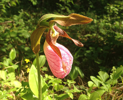
The trail skirts a spruce bog environment. Black spruce, sphagnum moss, pitcher plants, sundew and cottongrass are typical inhabitants of vast bogs such as this that cloak much of northern Ontario. Watch for moose, spruce grouse, gray jays and black-backed woodpeckers, which are also northern species. At this spot you may be lucky enough to encounter white-tailed deer which, in contrast, are more common to the south.
Payne’s Pine Trail eventually leads to a bayou-like silver maple swamp on the banks of the Little Bonnechere River. This lush green habitat is very reminiscent of flooded swamps of Rondeau Provincial Park, in Ontario’s Carolinian Zone on the north shore of Lake Erie, and points further south.
From this steep, sandy riverbank look upriver to find the twin trunks of Payne’s Pine, named after Canadian landscape artist Herschel Payne.
Herschel Payne was artist-in-residence at Bonnechere Park from 1995 to the early 2000s.
Pink pitcher plant along Payne's Pine Trail, which skirts a spruce bog environment.
One Foot at a Time
In the good old days, everyone traveled by foot – everywhere. In fact, it was not unusual for men to walk thirty kilometres or more to find work in the lumber camps, and the main foreman in a lumber camp was called the walking boss because of the distances he covered on foot. Legend has it that two settlement families who lived upstream from Basin Depot regularly walked more than twelve kilometres – one way – for their mail. Fire ranger and renowned Canadian artist Tom Thomson walked twenty kilometres from Grand Lake to Basin Depot for the same purpose.
The park rangers who patrolled Algonquin Provincial Park looking for poachers and fires, traveled the dusty trails in summer and snowshoed the same path-ways in winter. The late John Joe Turner recalled a chief fire ranger who walked from Killaloe “all the way up… clean through to Alder Creek at Lake Travers, and then he’d go on down the Petawawa and go out the other way” to Ottawa.
One wonders if the old folks who lived such long and productive lives did so because they walked to live.
HIghlights
spruce bog environment
wetlands
lakes
Little Bonnechere River
Payne’s Pine
15.6 km from Cty Rd 58. Trailhead off Basin Road, .4 km northwest of the Algonquin Park Boundary.
Rating: Easy
Type: Out and back to loop
Distance: 2.6 km
Time: 1 hour
Surface: Natural forest floor covered with pine needles.